I. Survey area overview
Hengsha Island, the ancient name of Liu Xiaogle. Located at the eastern end of the northeastern ministerial mouth of Baoshan District, Shanghai, it is the most petite of the three islands in Chongming County. Hengsha Island is a estuary sandbank formed near the mouth of the Yangtze River, and it is deposited as an alluvial island. Hengsha Island is one of the three major islands in the Yangtze River Estuary. It is located at the mouth of the Yangtze River and is surrounded by the river. Hengsha echoes Changxing and Chongming Island.
Basic situation of the survey area:
1. The vegetation is dense, especially in the woods and large areas of reeds. The GPS signals are often weak, even without signals, and data collection is not possible. At the same time, people need to endure the hot climate and face the threat of poisonous snakes and mosquito bites.
2, more silt, easy to sink, personnel are easy to fall into the quagmire during the measurement operation, security is not guaranteed;
3. In the shoal area, the water depth is shallow, and there is a region that the measuring ship cannot reach. The terrain is large and accompanied by silt, which greatly increases the difficulty of measurement.
Therefore, we use UAV measurement, the UAV measurement system has mobility, flexibility, safety, large-area observation, can make up for the defects of conventional measurement methods, and achieve the purpose of tidal flat and coastal zone mapping.
Second, the project implementation plan
This project uses the fixed-wing mapping drone with RTK/PPK to carry out aerial surveys on the survey area. Through the receiver placed on the ground reference station, the unmanned aerial vehicle GPS receiver continuously observes all visible GPS satellites and records 10HZ data. After the flight mission is completed, according to the dynamic post-processing principle of GPS, the base station data file and the POS file recorded by the aircraft are solved to obtain a high-precision POS file with a positioning accuracy of 2cm to 5cm, thereby obtaining high-precision aerial mapping. The results provide an accurate data reference for the measurement of tidal flats.
The photogrammetry of this project adopts the photogrammetry scheme based on GPS-assisted aerial triangulation. The workflow mainly includes two steps of the field and the internal industry. The specific process is shown in the following figure.
![[Surveying Case] ​​Shanghai Hengsha Island Aerial Photogrammetry](http://i.bosscdn.com/blog/21/06/23/591.jpg)
Figure 1 Flow chart 3, workflow
This project selects Taiwan carbon-based Avian fixed wing with RTK/PPK (commonly known as Bluebird), which has reliable performance, can have certain load, strong endurance and high safety factor. It has a take-off weight of 4.5kg, and the aerial camera uses a Sony ILCE-6000 camera with a focal length of 20mm and a pixel count of 24 million.
The operation process of low-altitude unmanned aerial vehicle aerial survey mainly includes route planning and design, image control point/checkpoint measurement, automatic air three solution calculation, stereo mapping, field mapping and mapping, and DOM production.
3.1 route planning and design
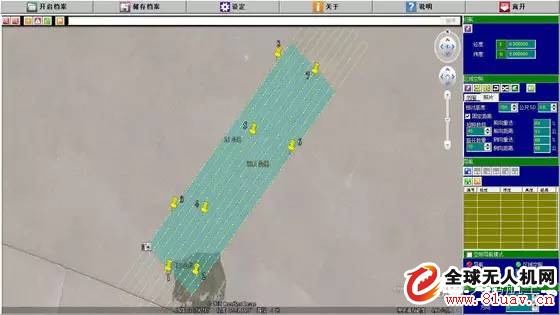
Figure 2 route planning design
3.2 Sample of control point layout
![[Surveying Case] ​​Shanghai Hengsha Island Aerial Photogrammetry](http://i.bosscdn.com/blog/21/08/59/191.jpg)
Figure 3 Sample diagram of image control point layout
3.3 Automatic empty three
In digital photogrammetry production operations, aerial triangulation (referred to as air three encryption) is one of the key processes, affecting the quality and efficiency of aerial survey products. The air three encryption is to determine the positioning and positioning of the entire measurement area, thereby obtaining the absolute coordinates of any point in the measurement area, and determining the external orientation elements of all the images in the area according to the provided orientation control points and the image orientation parameters, thereby obtaining The three-dimensional coordinates of the object space corresponding to the point.
The air three encryption of this project is completed by the Pix4D Mapper, which is marked by the aerial photography software. The software module is the POS auxiliary space triangulation, which can automatically generate the empty three report, and the quality of the photo can be checked through the report.
3.4 DEM build
On the basis of the system automatically reading and checking the project file, add images to perform single-machine multi-core parallel conversion image format. After the image format conversion is completed, a nuclear image is generated and the image is automatically matched. After the point cloud is extracted by software, the TIN is constructed using the filtered data and the DEM is constructed by using the building and vegetation filtering and the Z-value range filtering.
The DEM visualization module of the software is used to read in the DEM generated above. If there is a large rough point, it can be found on the DEM model, and the data preparation process is returned to the data processing. Secondly, in the software, the accuracy of the DEM is detected by the checkpoints measured on the stereo model, and a test report is generated. If there is an overrun point, the data processing process data is returned to the data preparation.
3.5 DOM color mosaic
Handling the color of low-altitude images is an important process in the DOM mosaic process. Generally speaking, the main factor affecting the final color quality of orthophotos is that the internal brightness distribution of a single image is not uniform, and the difference in color between multiple images is large. In the ortho mosaic system, a single image is matched and homogenized one by one by establishing a plurality of algorithms based on the template ratio, and a uniform color processing based on the Wallis filter is used among the multiple images, which solves the above problem well.
The in-line inlay line formed by the fast mosaic method is relatively regular, and can be easily and easily edited to solve the problem of local stitching lines and poor color tone.
Fourth, aerial photography project results
4.1 orthophoto map (DOM)
The DOM inlay for this project was completed by the Swiss Pix4D and Canadian C3D software (software name). On the basis of the system automatically reading and checking the project file, add images to perform single-machine multi-core parallel conversion image format. After the image format conversion is completed, a nuclear image is generated and the image is automatically matched. An orthophoto is produced on the basis of generating a TIN that is well fitted to the ground, and the elevated object/concave object leaving the ground surface must be added with the feature line to ensure the image of the elevated object/concave object. The vector is assembled and color balanced using a homogenizing software to generate the DOM.
![[Surveying Case] ​​Shanghai Hengsha Island Aerial Photogrammetry](http://i.bosscdn.com/blog/21/09/37/131.jpg)
Figure 4 Orthophoto image
4.2 Digital Surface Model (DSM)
DSM is a digital surface model, which can be a simulation of the surface of the ground, including the surface of the vegetation, the surface of the house. Processing the DSM, removing the house, vegetation and other information can form a DEM. The DEM must be elevation information and is a simulation of the surface.
In the field of surveying, topographic maps are a proper noun. It generally includes: measurement control points, residential areas, water systems, transportation, pipelines, landforms, vegetation, etc. The historical form of a digital topographic map is a simulated topographic map, usually paper. The topography on the topographic map is expressed by contour lines, elevation points, steep ridges, steep cliffs, and so on. Contours and elevations, plus steep ridges, steep cliffs and their ratios constitute an “elevation modelâ€. Through the interpretation of these, the overall impression of the surface elevation can be obtained, which is a simulation of the actual landform. Contours and elevation points on a digital topographic map are a type of digital elevation model. Irregular triangulation and regular grid can be digital elevation models. The core feature is that they can completely simulate the surface elevation information.
The area of ​​the flight operation is all in the field, and there is no other surface features, so the DSM model can roughly reflect the DEM digital elevation model.
![[Surveying Case] ​​Shanghai Hengsha Island Aerial Photogrammetry](http://i.bosscdn.com/blog/21/10/13/771.jpg)
Figure 5 DSM
V. Project accuracy assessment
Method: On the basis of the calculation of the regional network adjustment, check the error of the error and elevation in the plane position of the connection point to the nearest field control point. The DOM is superimposed with the topographic map, and the acquired coordinates on the DOM are compared with the same name of the topographic map to check whether the accuracy of the result meets the requirements.
5.1 Absolute orientation
The plane and elevation results of the regional network control points are taken from the RTK image control measurement data. After the calculation of the regional network adjustment is completed, the residual values ​​of the basic orientation points and the error of the checkpoint errors are counted.
The statistical results are reported in the report.
5.2 Field Accuracy Detection (Stereo Measurement)
In the field, the topographic map points are detected, and the error precision intervals in the topographic map points of the detected topographic maps are counted.
The DOM is superimposed with the topographic map, and the coordinates acquired on the DOM are compared with the points of the same name and the checkpoint coordinates of the topographic map.
In this experimental project, the UAVER_Avian_RTK UAV (Bluebird) was used for a flight of about 2 square kilometers in 30 minutes, and a total of 425 photos were taken.
The accuracy statistics of each result are as follows:
Control point (GCP)
![[Surveying Case] ​​Shanghai Hengsha Island Aerial Photogrammetry](http://i.bosscdn.com/blog/21/10/45/391.jpg)
Figure 6 control point map
The root mean square error of the control point in the X direction is 0.3 cm, the root mean square error in the Y direction is 0.7 cm, and the root mean square error in the Z direction is 0.9 cm.
Check Point
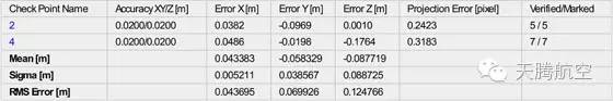
Figure 7 checkpoint map
The root mean square error in the X direction of the checkpoint is 4.3 cm, the root mean square error in the Y direction is 6.9 cm, and the root mean square error in the Z direction is 12.47 cm. The elevation requirements basically meet the experimental requirements.
This time basically achieved the purpose of this experiment, the plane coordinates of the checkpoint are controlled within 10cm, and the elevation error is controlled within 20cm.
It features small size, high reliability, cheap cost and good channel-to-channel uniformity, and is widely used in PON networks to realize optical signal power splitting.
XRX provides whole series of 1xN and 2xN splitter products that are tailored for specific applications.
The FBT Splitter has many years of technology and experience, the tow window splitter is fixed using a wavelength connecting device, commonly used as 1310/1490nm or 1310/1550nm. We can provide 1XN or 2XN configuration, Coupling Ratio is optional.
Dual Optical Splitter,Dual Window Fiber Splitter,Dual Window FBT Coupler ,Two Windows FBT Splitter
Chengdu Xinruixin Optical Communication Technology Co.,Ltd , https://www.xrxoptic.com